
Pilotshop.com
- Shop All Categories
- Browse Headsets


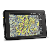
GARMIN AERA 660 NORTH AMERICA
MFR Model# 010-01518-00
 FREE Shipping

Overview
|
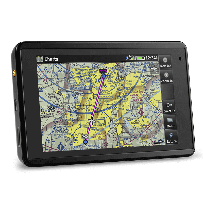
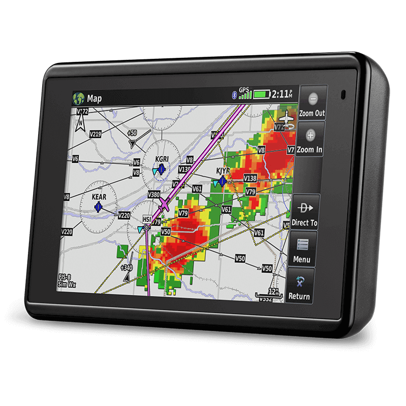
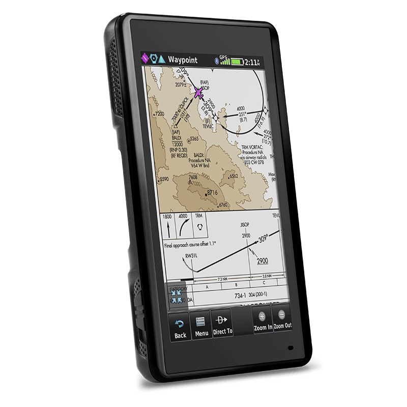
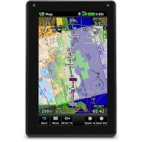
Affordable feature-rich navigation, stunning display and streamlined database updating 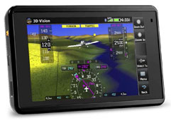 This compact 5-inch capacitive touchscreen boasts a bright, sunlight readable display complete with rich, interactive maps and a built-in GPS/GLONASS receiver that can be viewed in portrait or landscape modes for optimum customization. The aera 660 encompasses many of the features of the renowned aera® and GPSMAP® aviation portable series, adding Connext® wireless capabilities, Garmin WireAware wire-strike avoidance technology and more. Cost-effective database options along with built-in Wi-Fi® database updating capabilities allow customers to more easily access the most up-to-date data, including daily U.S. fuel prices. Bluetooth® supports the display of ADS-B In traffic and weather1 from a variety of sources, including the GDL® 39/GDL 39 3D, Flight Stream and the GTX 345 ADS-B transponder. This compact 5-inch capacitive touchscreen boasts a bright, sunlight readable display complete with rich, interactive maps and a built-in GPS/GLONASS receiver that can be viewed in portrait or landscape modes for optimum customization. The aera 660 encompasses many of the features of the renowned aera® and GPSMAP® aviation portable series, adding Connext® wireless capabilities, Garmin WireAware wire-strike avoidance technology and more. Cost-effective database options along with built-in Wi-Fi® database updating capabilities allow customers to more easily access the most up-to-date data, including daily U.S. fuel prices. Bluetooth® supports the display of ADS-B In traffic and weather1 from a variety of sources, including the GDL® 39/GDL 39 3D, Flight Stream and the GTX 345 ADS-B transponder.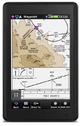 Dedicated Compact Portable Navigator The aera 660 features a 5-inch capacitive touchscreen display that is optimized for cockpits and various types of flying. An elegant yet rugged design allows the aera 660 to withstand harsh environments, meeting stringent temperature tests and helicopter vibration standards. The Garmin signature direct-to feature is always available so its easy to command navigation functions or find nearest airports from any page. A mini-USB connector, microSD card slot and removable battery accompany a dedicated power button along the bezel of the aera. Depending on settings and external connections, pilots will receive up to 4 hours of battery life on a single charge. An intuitive user interface resembles that of the popular GTN 650/750 touchscreen series, aera 795/796 series and the Garmin Pilot app, so pilots can easily transition between the aera 660 and other Garmin products in the cockpit. 3D Vision The 3D Vision page within the aera 660 leverages a worldwide terrain database to create a rich, 3D representation of rising terrain near the aircraft, while overlaying GPS-derived airspeed, altitude and vertical speed alongside flight plan information. 3D Vision also displays lateral and vertical (VNAV) deviation bars and includes a 360-degree HSI, which displays course deviation, track, bearing and more. Bearing pointers can be manually configured to identify the nearest airport, complete with distance information. When connected to the GTX 345, GDL 39 3D or Flight Stream, the 3D Vision presentation is further enhanced with the display of pitch, roll and slip-skid information. A pilot-selectable presentation optionally displays flight instruments in round gauges or tapes overlaid on the 3D topographic landscape. Connext Wireless Connectrivity Wireless connectivity options set the aera 660 even further apart from other portables on the market. Wireless database updating capabilities add to the unique feature set of the aera 660. When connected to Wi-Fi, pilots can easily download and update aviation databases without the need to physically connect the aera to a computer. Additionally, the aera 660 supports connectivity with the Garmin VIRB® XE HD action camera, so pilots can control recording and take photos. 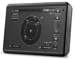 When paired with the GTX 345, Flight Stream or the GDL 39/GDL 39 3D, ADS-B traffic and weather1 is wirelessly transferred and displayed on the aera 660. ADS-B traffic information may be viewed on the moving map, IFR/VFR charts and dedicated traffic pages, which also leverages patent-pending features such as TargetTrend and TerminalTraffic. Traffic trajectories and potential conflicts are easier to identify with TargetTrend, which incorporates relative motion technology to help pilots visualize the future position of nearby traffic targets relative to the aircraft. The traffic picture is further enhanced during taxi, takeoff and landing with TerminalTraffic, which detects and displays other aircraft or ground vehicles on runways or taxiways that are also broadcasting ADS-B position information. SafeTaxi® geo-referenced airport diagrams also aid in situational awareness by identifying runways, taxiways, FBOs, hangars and more relative to the aircrafts position on the airport surface. Subscription-free Flight Information Service-Broadcast (FIS-B) weather1 products may simultaneously be overlaid on the map page and dedicated weather pages for easy interpretation. Weather-related decision-making is easier with the aera 660, which helps pilots interpret datalink NEXRAD radar more easily by animating this imagery. Additionally, multiple weather products can be overlaid on a single weather page for better analysis. When paired with the GTX 345, Flight Stream or the GDL 39/GDL 39 3D, ADS-B traffic and weather1 is wirelessly transferred and displayed on the aera 660. ADS-B traffic information may be viewed on the moving map, IFR/VFR charts and dedicated traffic pages, which also leverages patent-pending features such as TargetTrend and TerminalTraffic. Traffic trajectories and potential conflicts are easier to identify with TargetTrend, which incorporates relative motion technology to help pilots visualize the future position of nearby traffic targets relative to the aircraft. The traffic picture is further enhanced during taxi, takeoff and landing with TerminalTraffic, which detects and displays other aircraft or ground vehicles on runways or taxiways that are also broadcasting ADS-B position information. SafeTaxi® geo-referenced airport diagrams also aid in situational awareness by identifying runways, taxiways, FBOs, hangars and more relative to the aircrafts position on the airport surface. Subscription-free Flight Information Service-Broadcast (FIS-B) weather1 products may simultaneously be overlaid on the map page and dedicated weather pages for easy interpretation. Weather-related decision-making is easier with the aera 660, which helps pilots interpret datalink NEXRAD radar more easily by animating this imagery. Additionally, multiple weather products can be overlaid on a single weather page for better analysis.Fuel Prices, Global Charting Options and More Comprehensive chart options provide pilots with an easy path to a paperless cockpit in a compact device, which may be qualified for use as either a Class I or Class II Electronic Flight Bag (EFB). Geo-referenced IFR enroute, VFR sectional charts and Garmin FliteCharts® terminal procedures are available as part of the expansive database offerings associated with the aera 660. Using FliteCharts, pilots can easily view departure procedures (DPs), standard terminal arrival routes (STARs) and geo-referenced approach charts. Additionally, Garmin ChartView enables the display of Jeppesen charts with an optional subscription from Jeppesen. U.S. fuel price data is easily accessible on the map or within the airport directory database, so its easy to identify the lowest price of 100 LL and Jet A in the area. Similar to features found within other Garmin products, patented Smart Airspace is included in the aera 660 feature set. Smart Airspace highlights the airspace nearest the aircrafts current altitude and de-emphasizes non-pertinent airspace so pilots can quickly identify their location relative to the airspace around them. Using the optional global navigation database and many regional charting options, the aera 660 provides worldwide versatility. The aera 660 is available in 4 regional versions with select regional data preloaded for North America, South America, Atlantic and Pacific regions. While each version is only available for purchase from Garmin in the corresponding region, regional databases can be purchased for any unit from any region. For pilots in Europe, the Atlantic version of the aera 660 includes the Enhanced Basemap, which provides VFR operators with more visual landmarks and intersections that are often used when contacting air traffic control. Additionally, when selecting a street or intersection on the moving map of the aera, street names populate so its easier to identify aircraft location while navigating over an urban or unfamiliar environment. 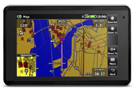 Helicopter Optimization Helicopter Optimization
The aera 660 contains built-in features tailored to helicopter operators, including Garmin WireAware wire-strike avoidance technology. WireAware overlays power line locations and relative altitude information on the moving map and provides both aural and visual alerting when operating near power lines. Altitude display is offered in both mean sea level (MSL) and above ground level (AGL), so they are easier to identify relative to the aircraft flight path. The standard obstacle database contains Hazardous Obstacle Transmission (HOT) lines, which typically include those that span rivers, canyons, valleys or those that are within the vicinity of airports. Obstacle databases with comprehensive power line coverage and HOT lines are also available for the U.S. and portions of Canada and Mexico. Additionally, VFR helicopter chart coverage throughout eight major metropolitan areas within the U.S. depict helicopter airways and routes, heliports with associated frequency and lighting capabilities, NAVAID information and obstructions. Coverage for the Gulf of Mexico is also available, which includes offshore oil drilling platforms and more. Operators may also incorporate City Navigator® NT street maps to enable address look-up functions within the aera to easily navigate to street intersections during off-airport operations. 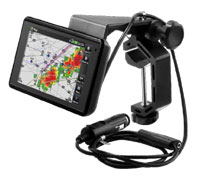 Connect with Garmin Avionics Connect with Garmin Avionics
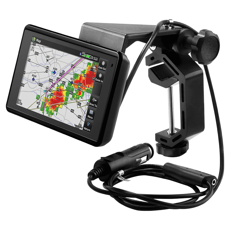
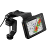
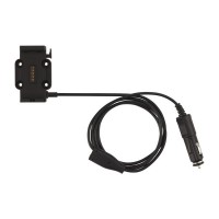
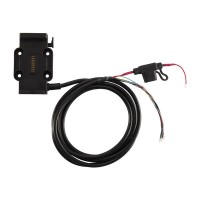
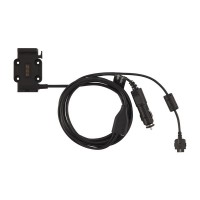
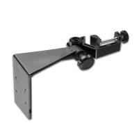
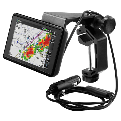
The aera 660 includes a yoke mount and cigarette lighter adapter as a standard accessory (pictured). Pilots can also connect an optional bare wire cable to the aircraft instrument panel and expand the utility of the aera 660 by utilizing power, audio and dual RS-232 connections. When paired with a navigator such as the GTN 650/750 touchscreen series or the GNS 430W/530W, the aera can receive flight plan data entered into the navigator over a serial port and remain synchronized throughout the flight. When connected to a NAV/COM such as the GTR 225, GNC 255, GTR 200, SL 30 or SL 40, frequencies and airport identifiers can also be transferred from the aera to the corresponding NAV/COM. Additionally, ADS-B traffic and weather1 can be transferred via the wired connection to the aera 660 when linked to the GTX 345, GDL 39 or GDL 39 3D. Low-Cost Database Options The Garmin Navigation Database available for North America offers a cost-effective path to incorporate the latest database information into the aera 660. Navigation data includes the option to load and activate instrument approach procedures, load flight plan data and more. The Garmin Navigation Database has an option for a single update. There are also a variety of cost-effective annual bundles available, such as the U.S bundle, which includes the Garmin Navigation Database, FliteCharts®, IFR/VFR Charts, Terrain, Obstacles, SafeTaxi® and the AOPA Airport Directory with fuel prices. For worldwide coverage, Jeppesen NavData is also available for purchase. Please check flyGarmin.com for current pricing and ordering. Once purchased, these databases can be conveniently downloaded and updated on the aera 660 via Wi-Fi. With its long list of features, the aera 660 combines many of the capabilities of panel-mounted avionics with a value-packed, purpose-built package. Its a dedicated aviation portable thats ready to fly, right out of the box. |

WARNING: Cancer and Reproductive Harm - www.P65Warnings.ca.gov. |
Features
- 3D Vision
- Wireless Database Updating
- Garmin WireAware
- Connext®
- TargetTrend (When paired with compatible devices)
- TerminalTraffic (When paired with compatible devices)
- Smart Airspace
- Preloaded Garmin FliteCharts®
- Animated NEXRAD (When paired with compatible devices)
- SafeTaxi®
- Fuel Prices
- VIRB® XE Control
Specifications
- Physical Dimensions: 5.5W x 3.4H x .8D (14.1 x 8.7x 2.1 cm)
- Display Size: 4.35W x 2.61H (11.1 x 6.6 cm); 5.08 diag (12.9cm)
- Display Resolution: WxH: 480 x 800
- Display Orientation: portrait and landscape
- Display Type: touchscreen WVGA color TFT with backlight
- Weight: 8.64 ounces (245 g), with battery
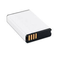
- Battery: removable, rechargeable lithium-ion
- Battery Life: Up to 4 hours during typical use
- GPS Receiver: SBAS/WAAS/GLONASS
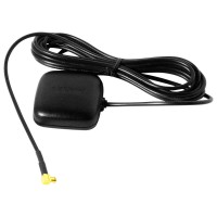
- GPS Antenna: Built-in, optional external antenna (not included)
- Removable Memory Slot: Yes (microSD compatible)
- Wireless Connectivity: Wi-Fi®, Bluetooth®, ANT+®
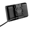
In The Box
- aera 660
- Yoke mount with power cable - 5ft
- Battery
- AC adapter
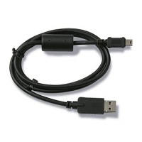
- USB cable
- Quick start manual and related documentation
Videos


Reviews
Perfect for VFR navigation and very portable. Can be panel mounted with an AirGizmo dock. Requires a Garmin subscription for periodic updates. Add a GDL 50 for ADSB - in traffic and weather. Good bang for the buck.
GARMIN AERA 660 NORTH AMERICA
Fast service from Spruce. 660 is substantial improvement over the 496 it replaced. Very easy to use.
GARMIN AERA 660 NORTH AMERICA
They says North America but I have just the Canada. I have to buy to get US…
GARMIN AERA 660 NORTH AMERICA
Stellar portable gps, hands down. Great size to mount in panel with a Gizmos.
GARMIN AERA 660 NORTH AMERICA
Worked great.
GARMIN AERA 660 NORTH AMERICA
I wondered why these still exist with the tablet apps and if a standalone GPS aviation portable had any value. I found out the 660 is an incredible device with almost all the features of Garmin’s panel navigators when mounted in an Air Gizmos dock. It communicates GPS position to the GTR 225 Com radio and transfers frequencies from the screen to Standby. It transfers flight plans and changes from the 660 to/from ForeFlight or Garmin Pilot. With the GDL 50 ADS-B receiver it displays weather and traffic right on the screen in front of the pilot. My C150 now has the capability of a VFR jetliner for a fraction of the cost.
GARMIN AERA 660 NORTH AMERICA
Excellent product
GARMIN AERA 660 NORTH AMERICA
I upgraded from the Garmin 496GPS and the Garmin Aera 660 is now installed on my RV-7A panel and working well with my AFS displays and Trutrack autopilot
GARMIN AERA 660 NORTH AMERICA
Very Nice...super easy to use
GARMIN AERA 660 NORTH AMERICA
Just what I needed easy to use
GARMIN AERA 660 NORTH AMERICA
Q&A
Please note, Pilotshop.com's personnel are not certified aircraft mechanics and can only provide general support and ideas, which should not be relied upon or implemented in lieu of consulting an A&P or other qualified technician. Pilotshop.com assumes no responsibility or liability for any issue or problem which may arise from any repair, modification or other work done from this knowledge base. Any product eligibility information provided here is based on general application guides and we recommend always referring to your specific aircraft parts manual, the parts manufacturer or consulting with a qualified mechanic.
The new Garmin Navigation Database available for North America offers a cost-effective path to incorporate the latest database information into the aera 660. Navigation data includes the option to load and activate instrument approach procedures, load flight plan data and more. The new Garmin Navigation Database starts at $29.95 for a single update. A variety of cost-effective annual bundles are also available, such as the U.S bundle for $149.95, which includes the Garmin Navigation Database, FliteCharts®, IFR/VFR Charts, Terrain, Obstacles, SafeTaxi® and the AOPA Airport Directory with fuel prices. For worldwide coverage, Jeppesen NavData is also available for purchase. Once purchased via flyGarmin.com, these databases can be conveniently downloaded and updated on the aera 660 via Wi-Fi.
No, this can be used for ADS-B in display only.
Yes, two RS-232 connections are available for data sharing. The 496 series only had one.
Yes, all registered lakes and rivers will display a name. Unregistered lakes may appear with or without a name.
Central America would be covered by part # 10-06025 which is for North and Central America.
The dimensional profile's of the Garmin Aera 500 and the Aera 660 are very different. If the mount for the 500 is an AirGizmos panel mount or another mount that takes the exact shape of the 500 it will not work for the 660.
Yes, geo-referenced charts are displayed on the 660.
The North American database includes Flitecharts, IFR/VFR charts, terrain and obstacles. Obstacles and charts for Canadian pilots are included in the North American database. Additional databases are available on the Garmin website.
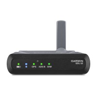
Both the first generation and the 3D models of the Garmin GDL 39 will work with the Aera 660.
Yes, the Aera 660 includes waypoint transfers and GPS tracks.